
Search Term Record
Metadata
Name |
Surveying |
Related Records
-

-
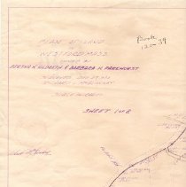
W.2019.19.1 - Survey, Land
Plan of Land in Westford Mass owned by Bertha H. Hildreth and Barbara H. Parkhurst Surveyed Dec 27, 1974 by Richard L. McGlinchey, Book 120-39 Sheet 1 & 2 taped together. Written on the back is " Hildreth Farm - R. McGlinchey 1974 58 Hildreth St Westford and Hildreth Hills Condos" Westford Water Company water tower is drawn in. (21.5" x 38")
Record Type: Object
-
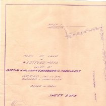
W.2019.19.2 - Survey, Land
Plan of land owned by Bertha H. Hildreth & Barbara H. Parkuurst Dec. 27, 1974 by Richard L. McGlinchey. Sheet 2 of 2. Duplicate of sheet two in W.2019.19.1 except this copy has no pencil drawings of Hildreth Hills, the top of Burns Hill, or the Westford Water Company tower. (21" x 15.5" )
Record Type: Object
-
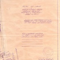
W.2019.19.3 - Survey, Land
Plan of Land in Westford Mass. Surveyed Feb 24, 1975 by Richard L. McGlinchey. Showing proposed water tower site and access road by the Town of Westford. (21" x 15.5")
Record Type: Object